Options
The InaSAFE plugin provides an options dialog which allows you to define various options relating to how InaSAFE will behave. The options dialog can be launched by clicking on the InaSAFE plugin toolbar’s Options button (as shown below) or by going to .

Options button
This following dialog will appear, which is divided into three tabs:
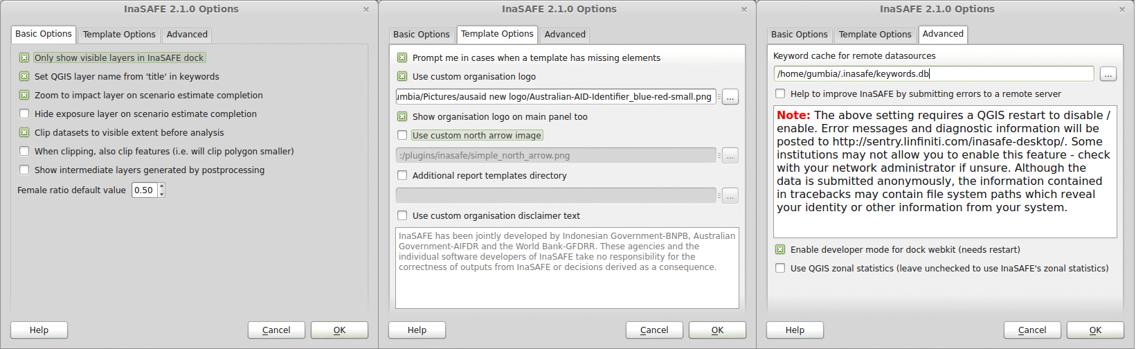
Options dialog
The following options are available on the Options Dialog:
Basic Options
Only show visible layers in the InaSAFE dock: This option will determine whether all hazard and impact layers should be listed in the InaSAFE dock’s combo boxes or (when checked) only visible layers.
Set QGIS layer name from ‘title’ in keywords: This option will cause QGIS to name layers in the Layers tree using the title keyword in the layer’s keywords file. If the layer has no ‘title’ in its keywords, or it has no keywords at all, the normal QGIS behaviour for naming layers will apply.
Zoom to impact layer on scenario estimate completion: This option will cause the map view to zoom in/out in order to completely contain the InaSAFE impact scenario map output when an analysis completes.
Hide exposure layer on scenario estimate completion : This option will cause QGIS to turn off the exposure layer used when InaSAFE completes the current analysis. You can re-enable the layer visibility again by checking its checkbox in the legend.
Clip datasets to visible extent before analysis: This option will cause QGIS to clip hazard and exposure layers to the currently visible extent on the map canvas.
When clipping, also clip features (e.g. will clip polygon smaller): This option will clip any polygons that extend beyond the analysis extents so that they are contained by the analysis extent. For example if you have a flood hazard polygon layer that extends far beyond your area of interest, the flood polygons will be reduced so that only the part inside of your area of interested is retained. This can speed up processing time.
Show intermediate layers generated by postprocessing: This option will cause QGIS to show the intermediate files generated by the postprocessing steps in the map canvas.
Female ratio default value: This is the default female to total population ratio used for generating gender breakdowns.
Template Options
Prompt me in cases when a template has missing elements: When enabled, this option will cause InaSAFE to prompt the user when a template has a missing element if the user tries to print the report or open it in the composer.
Use custom organisation logo: This option is used to determine the custom logo that will be used as an organisational logo in the PDF of your impact scenario project. If this option is disabled, InaSAFE will use the default organisation logo. See Reports in the InaSAFE User’s Manual for more information on the reports.
Show organisation logo in the main panel too: If this is enabled then the selected organisation logo (if any) will be displayed in the bottom of the InaSAFE dock panel.
Use custom north arrow image: This option is used to determine a custom north arrow that will be used as the north arrow image in the PDF of your impact scenario project. If this option is disabled, InaSAFE will use the default north arrow image.
Additional report templates directory: This option is used to determine a directory with custom templates. Templates from this directory will be available for use when generating reports in your impact scenario project.
Use custom organisation disclaimer text: This option is used to change the default disclaimer text printed in reports. If this is enabled, enter your own text and it will be used instead of the default one. See Reports in the InaSAFE User’s Manual for more information on the reports.
Advanced
Keyword cache for remote datasources: This option is used to determine where keywords are stored for datasets when it is not possible to write them into a
.keywordsfile. See Keywords System in the InaSAFE User’s Manual for more information on the keywords system.Help to improve InaSAFE by submitting errors to a remote server: This option, when enabled, will submit diagnostic information back to an InaSAFE project server in the event of any error taking place that we are able to trap. The information provided is useful to the InaSAFE team to improve the robustness of the software and to spot trends in issues people encounter. Please note the warning text below this option which is included here in full:
Note
The above setting requires a QGIS restart to disable/enable. Error messages and diagnostic information will be posted to http://sentry.linfiniti.com/inasafe-desktop/ . Some institutions may not allow you to enable this feature - check with your network administrator if unsure. Although the data is submitted anonymously, the information contained in tracebacks may contain file system paths which reveal your identity or other information from your system.
Enable developer mode for dock webkit (needs restart): With this option enabled, you can right-click on the report area and use the webkit debug tools to debug the output. This option is intended for advanced users only.
Use QGIS zonal statistics: With this button you can toggle between using QGIS internal zonal statistics or the one that comes with InaSAFE.
Note
You can click on the Help button at any time and it will open the help documentation browser to this page.
Note
Pressing Cancel at any time will close the options dialog and any changes made will not be applied. Pressing OK at any time will close the options dialog and any changes made will be applied immediately.
Note
The exact button order shown on this dialog may differ depending on your operating system or desktop environment.