User Extents
As of version 2.2, it is possible to explicitly define the extents that should be used for the analysis. You can use the new to invoke the extents selection dialog.
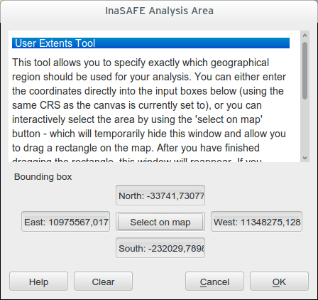
User extents dialog
It is important do understand the logical workflow for your custom defined extents and their relation to the layer and viewport extents. There are three possible permutations for the basic extents clipping behaviour:
- No clipping: use full extents of the union of the hazard and exposure
datasets regardless of your current viewport (where you are zoomed to on the map. You can enable this behaviour in the options dialog by unticking Clip datasets to visible extents before analysis.
- Clip to visible viewport extents: use the common overlapping area of
hazard, exposure and the current extents for the analysis (enable this behaviour by ticking Clip datasets to visible extents before analysis).
- Clip to the user defined extents: use the common overlapping area of
hazard, exposure and the user defined extents for the analysis (enable this behaviour by using ).
When you select an area using the user extents dialog (either by pressing the Select on map button, or by manually typing the extents coordinates) the user extent will be shown with a blue rectangle on the map if you have rubber band previews enabled. Creating a user defined analysis extent will enable the third behaviour described above, and any analysis done will disregard the current viewport extents and only consider the intersection of the user defined analysis ares and the hazard and exposure layers.
Note: To disable user defined extents, then click the clear button.